 |
 |
| 現在の価格 | ¥ 600(2024/04/15 更新) |
| カテゴリ | ナビゲーション |
| 評価 |
(0)
|
| 対応デバイス | iPhone iPad |
OkMap Mobile is easy to use and its features are similar to those of the most popular GPS handhelds.
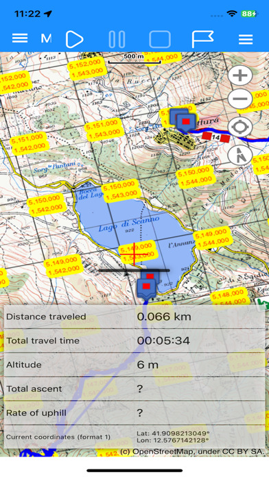
Plan your routes on the map! OkMap calculates the height differences and travel times for you and produces statistics and graphics.
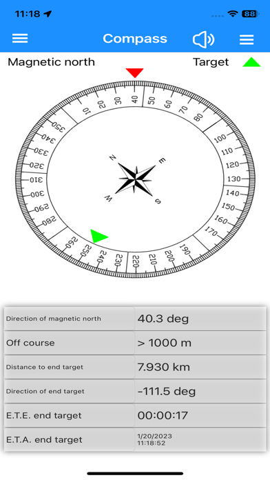
A compass shows you the direction and you will be warned if you are going off course.
OkMap is specially designed for those who do outdoor activities such as search and rescue, hiking, mountain biking, off road, boating, flying, hunting and fishing, mushroom hunting, geocaching, soft air and much more.
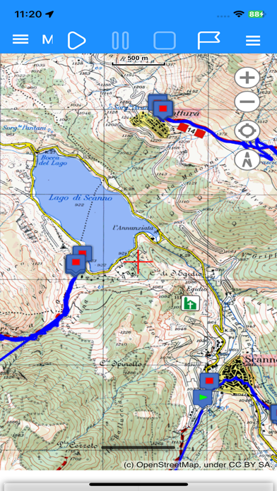
OkMap works with different online maps and offline custom maps in MbTiles format.
You can use your favorite digital maps both acquired and scanned!
Furthermore OkMap works with GPX files, the standard format for storing waypoints, tracks and routes.
These files can be copied to and from the PC via cable or via Google Drive.
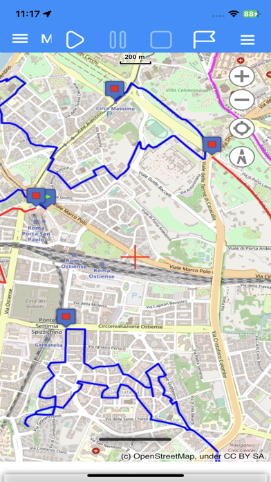
You can record the track while walking on a trail and/or follow a previously recorded or created track.
All waypoints, tracks and routes are displayed on the map; the recording track is drawn in real time.
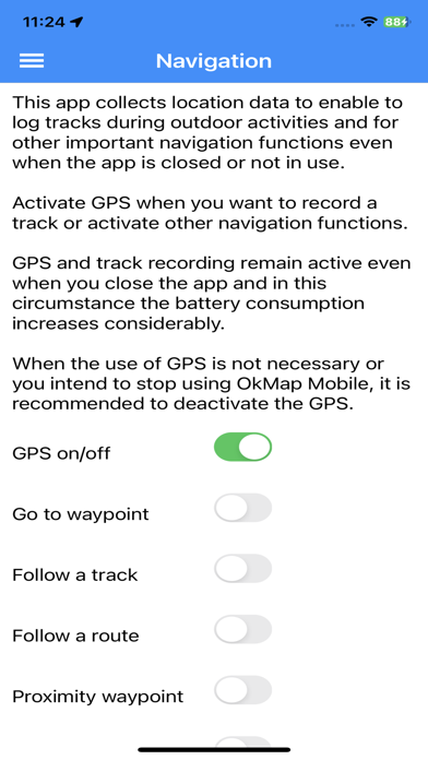
OkMap records the tracks even in standby and with the app closed. A notification alerts you when the GPS is working.
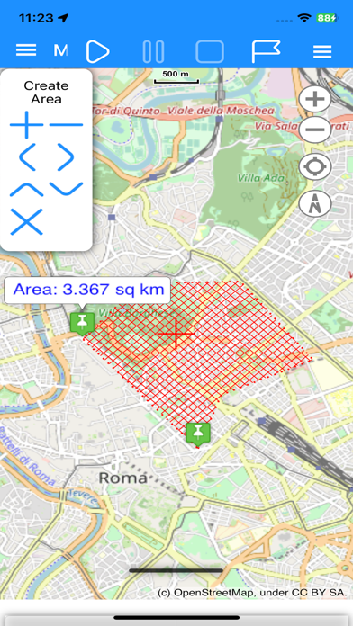
You can create and edit waypoints, tracks and routes directly on the map.
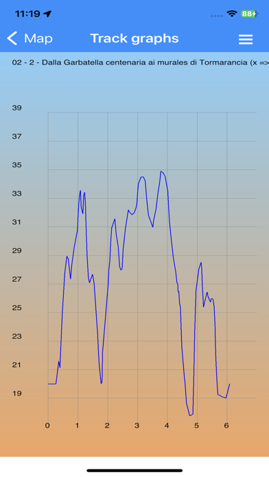
It is also possible to produce different types of statistics and graphs on your own tracks.
Finally, an augmented reality function displays all waypoints with altitude in the device's camera.
FUNCTIONS
Maps
- Offline custom map in MbTiles format
- Online maps from different TMS and WMS web servers (Google, Apple, OpenStreetMap, ESRI, Nokia, etc ...)
- Addition of new custom web servers
- 6 customizable navigation and status indicators (from over 60)
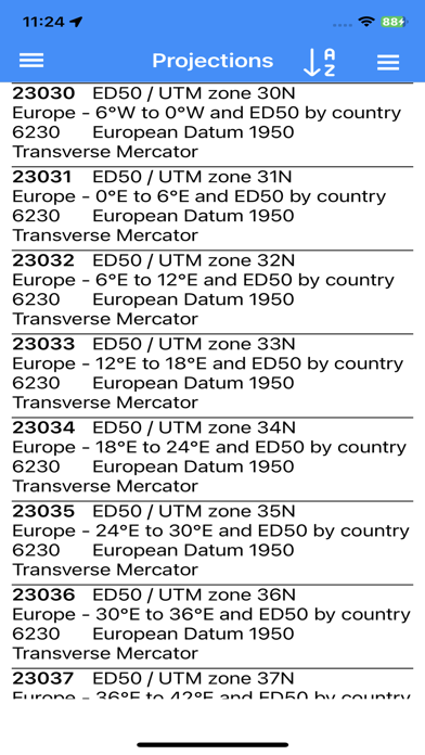
- Coordinates in different datums and formats: Degrees, Degrees-Minutes, Degrees-Minutes-Seconds, UTM, ECEF, OLC, GeoRef, USNG, MGRS, BNG, IG, metrics according to many projections
- Zoom on: GPX data, copied coordinates
- Mode: follow the user's position, distance calculation
- Grids: geographic, metric and DEM data
- Find: waypoint, track, route, address, coordinates
- Reverse geocoding
- Waypoint generation
- Download and management of elevation data (DEM) from the SRTM project
- Integration with: Google Maps, Geocaching.com, Peakfinder.org
- Download waypoints from OpenStreetMap
- Create and edit waypoints, tracks and routes on the map
Navigation
- GPS activation/deactivation
- Start, pause and stop recording of the track
- Stores waypoint at current location
- Navigate to a waypoint and follow a track or a route
- Waypoint proximity function
- Anchor alarm
- Off course alarm
- Sending values via email
- Sending current position and waypoints to a remote OkMap server
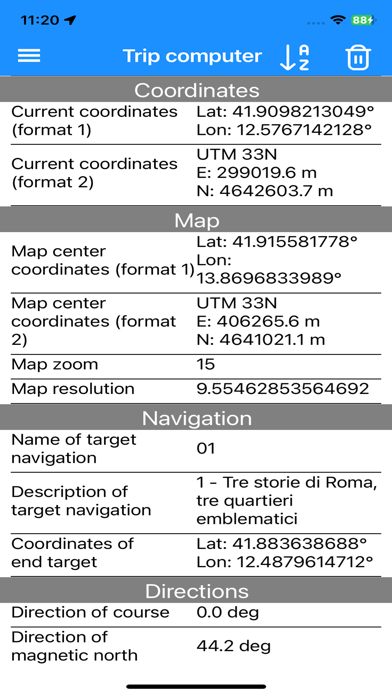
Trip Computer
- On-board computer with over 60 navigation and status indicators
Compass
- 6 customizable navigation and status indicators (from over 60)
- Graphic compass with direction of north and destination
- Speech synthesizer when pointing the device
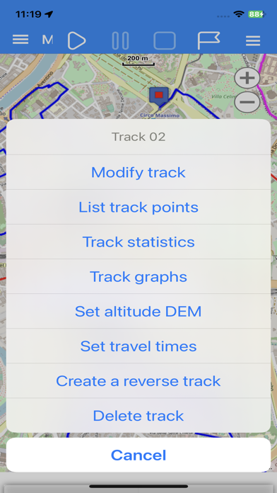
Waypoints, Tracks and Routes
- Lists of various kinds
- Edit and delete functions
- Sorting and filtering functions
- Information detail pages
- Track graphs
- Track statistics
- Track and route inversion
- Automatic attribution of altitudes
- Travel time estimation function
Utility
- List of GPX file
- List of custom maps
- List of downloaded DEM files
- List of web maps
- List of datum
- List of projections
- Preferences
- Reset to factory settings
- Information and links
- Download the online manual
Plan your routes on the map! OkMap calculates the height differences and travel times for you and produces statistics and graphics.
A compass shows you the direction and you will be warned if you are going off course.
OkMap is specially designed for those who do outdoor activities such as search and rescue, hiking, mountain biking, off road, boating, flying, hunting and fishing, mushroom hunting, geocaching, soft air and much more.
OkMap works with different online maps and offline custom maps in MbTiles format.
You can use your favorite digital maps both acquired and scanned!
Furthermore OkMap works with GPX files, the standard format for storing waypoints, tracks and routes.
These files can be copied to and from the PC via cable or via Google Drive.
You can record the track while walking on a trail and/or follow a previously recorded or created track.
All waypoints, tracks and routes are displayed on the map; the recording track is drawn in real time.
OkMap records the tracks even in standby and with the app closed. A notification alerts you when the GPS is working.
You can create and edit waypoints, tracks and routes directly on the map.
It is also possible to produce different types of statistics and graphs on your own tracks.
Finally, an augmented reality function displays all waypoints with altitude in the device's camera.
FUNCTIONS
Maps
- Offline custom map in MbTiles format
- Online maps from different TMS and WMS web servers (Google, Apple, OpenStreetMap, ESRI, Nokia, etc ...)
- Addition of new custom web servers
- 6 customizable navigation and status indicators (from over 60)
- Coordinates in different datums and formats: Degrees, Degrees-Minutes, Degrees-Minutes-Seconds, UTM, ECEF, OLC, GeoRef, USNG, MGRS, BNG, IG, metrics according to many projections
- Zoom on: GPX data, copied coordinates
- Mode: follow the user's position, distance calculation
- Grids: geographic, metric and DEM data
- Find: waypoint, track, route, address, coordinates
- Reverse geocoding
- Waypoint generation
- Download and management of elevation data (DEM) from the SRTM project
- Integration with: Google Maps, Geocaching.com, Peakfinder.org
- Download waypoints from OpenStreetMap
- Create and edit waypoints, tracks and routes on the map
Navigation
- GPS activation/deactivation
- Start, pause and stop recording of the track
- Stores waypoint at current location
- Navigate to a waypoint and follow a track or a route
- Waypoint proximity function
- Anchor alarm
- Off course alarm
- Sending values via email
- Sending current position and waypoints to a remote OkMap server
Trip Computer
- On-board computer with over 60 navigation and status indicators
Compass
- 6 customizable navigation and status indicators (from over 60)
- Graphic compass with direction of north and destination
- Speech synthesizer when pointing the device
Waypoints, Tracks and Routes
- Lists of various kinds
- Edit and delete functions
- Sorting and filtering functions
- Information detail pages
- Track graphs
- Track statistics
- Track and route inversion
- Automatic attribution of altitudes
- Travel time estimation function
Utility
- List of GPX file
- List of custom maps
- List of downloaded DEM files
- List of web maps
- List of datum
- List of projections
- Preferences
- Reset to factory settings
- Information and links
- Download the online manual